A new generation of scientists monitor the Ashley/Rakahuri River
Rangiora High School students learn about their local river the Ashley/Rakahuri and how we keep track of its health.
Earlier this year, a Rangiora High School geography class asked us if we could help a group of their students find out more about the issues affecting their local river, the Ashely/Rakahuri.
“Students were particularly interested in why parts of the awa had become unsuitable for swimming over the summer,” said their teacher Rebecca Sweney-McKee.
Staff from our Zone Delivery, Science and Youth Engagement teams met the young people at the river and showed them how to collect samples, take measurements and evaluate the environmental conditions they saw.
The data the students collected during the trip will go towards their first NCEA standard about understanding an environment using data.
How do we know what “good water quality” means for a river?
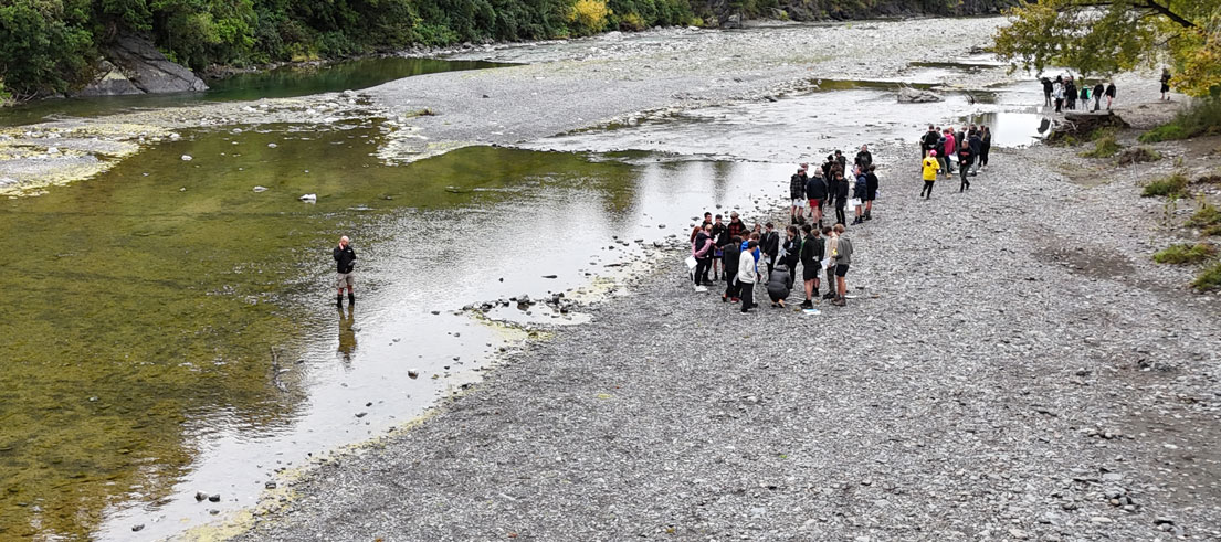
To answer this question, the students’ trip began at the Ashely Gorge, the ‘control location’ for water quality sampling on the Ashely/Rakahuri.
Radford Gulliver, our Science Field Team Leader, explained that to understand the health of a river as it flows through changing landscapes, we need to do monitoring at more than one location, and we need a 'control location'. A control location gives us an unbiased starting point to use to compare with the samples taken downstream.
“The control location is a part of the river unimpacted by surrounding land use that’s as close as possible to its natural state,” said Radford.

Science Field Team Leader Radford Gulliver addresses the students from Rangiora High School
Regional councils use the data they collect at different locations on a river to track changes over time, and pinpoint factors that might be affecting water quality or flooding issues.
Wading in on the issue of water quality
At the control location, students were encouraged to evaluate the surrounding land and notice the thick native bush that rainwater flows through before entering the river. This led to a discussion about riparian planting and the way that native plants can filter water after rainfall.
Students were shown how to take water samples and consider its clarity and temperature - both important indicators of the presence of algae. Certain types of algae can affect the quality of water for recreation, the issue that prompted the students' research.
They also learned how to evaluate a river’s morphology (shape) and about nature’s scrubbing brush – substrates. Substrates are the boulders, stones and sand that make up the bottom of a river. As the river flows, they jumble together to scrub the bottom of the riverbed. This helps reduce the buildup of algae and ensure the oxygen levels are suitable for aquatic life.
To find out what is underneath the river, students measured a quadrant (or small sample area) of the riverbank to find out what it's made up of – large stones, small stones, sand or sediment. This tells us about how the channels in a river are moving and working and what might happen when the river is high.

Students learn how to measure a quadrant of riverbank

Collecting water samples from the river

Examining water clarity for the presence of algae
What do we know about flooding?
Monitoring water volume is another important role for regional councils. Councils need to know about the capacity of our rivers and how much room they have to move when in flood. This tells them how much water can be taken and what flood prevention work may be needed.
During their trip, students measured the width of the river and examined the flood plain. They were challenged to find the difference between the water’s height and the edge of the containment area.
We know that flooding is a natural process that can help water quality by churning up substrates and flushing out the river - but how we manage it is an important question for the future. How much can we allow rivers to move, flood and change course? Can we expect them to move within the boundaries we create?
Empowering young scientists
Waimakariri Zone Lead, Nerida Theinhardt, coordinated our input into the trip and shared her knowledge around native plants and their role in protecting water quality.
“I really believe that this is the generation that will make a change for Canterbury. It’s so important as a regional council that we explain to our young people how we monitor our environment, why this data is important, and how we use it to inform decisions on water quality, water take and flooding.”
Teacher Rebecca Sweney-McKee said the trip provided valuable learning for her students and plans to continue their learning beyond the classroom.

Waimakariri Zone Lead, Nerida Theinhardt, shares her knowledge of native plants
“They took a lot of new knowledge and understanding away with them. We are very grateful for the expertise the Environment Canterbury team were willing to share with our students and staff. We will definitely be looking to work together on similar exploits in the future.”